
I got up before sunrise and headed out to the trailhead at the end of the park road. I knew that this was a popular trail, so I wanted to get out early to avoid the crowds. As I parked at the trailhead, the sun had just risen above the horizon. I was the third car to arrive for the morning, but I soon discovered that the other two visitors had only come for sunrise and I encountered them both heading back to their cars as I started the trail.
The first big arch on the trail is landscape arch, the longest arch in the world. This first mile of the trail is well-developed and sees lots of visitors. After this point, hikers have to scramble up a pretty steep and long section of boulders which is probably the least well-signed part of the whole trail. I wondered if this was done on purpose to keep un-prepared hikers out.
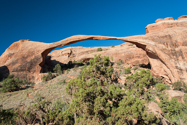
Landscape arch

Looking back over a steep and poorly-signed section
The trail climbed steeply up to two more arches, Partition Arch and Navajo Arch. It was still pretty cool so the climbing was easy. In addition to the arches, there were lots of interesting rock formations along the way, too.

View through Partition Arch

These rock formations look like the silhouettes of people gathering
One of the perks of being the first person on a trail in the morning is to see all the little critter paw prints from the previous night, and there were lots of them here. I saw tons of prints from tiny chipmunks and rabbits, a couple of coyotes, and a big raven.

Chipmunk tracks
Next the trail led into a section of big rock fins. Sometimes the path led over the spine of a big fin, and other times it wound its way through the fins along deep chasms. There were a few more arches tucked away among the fins, too.

Rock fins -- I'm standing on the spine of one for this photo

Double O Arch

The aptly-named Private Arch, which was quite a trek to get to from the main trail
After making it through some scrambles to get out of the rock fins, the trail follows a dry riverbed and flattens out a bit. Then it climbs back up to join Landscape Arch, but not before winding through some interesting rock spires.

Rock formations at the end of the trail
By the time I got back to the car around 10am, the parking lot was full and lots of people were making their way to Landscape Arch for pictures. After lunch at the super yummy Quesadilla Mobilla in town, Matt and I decided to head back over to Canyonlands for the rest of the day, this time exploring The Needles section of the park. Here, we went on a couple of short hikes (Cave Spring and Roadside Ruin) to see petroglyphs, small ancient ruins, and an abandoned cowboy camp from the 1930's. The rock formations on this side of the park resemble enormous toadstools -- round with big overhangs that made a nice spot for native peoples and cowboys alike.

Newspaper Rock, just outside the park entrance

Petroglyphs near a seep spring

Ladder up to the top of the rock formations

Posing for a picture along the underside of one of the toadstools

No comments:
Post a Comment
Please log into your Google or Gmail account first before typing a comment, otherwise blogger will take you to a login page when you hit "publish" and your comments will be lost!