Saturday, October 3, 2015

Getting to know the neighborhood

We've officially been Seattle residents for 2 whole months now, and it's beginning to feel like home.  Matt and I have been exploring our new neighborhood and taking lots of walks around Green Lake trail, which is just a few miles from our house.  We also caught the tail end of the neighborhood farmers markets in September, and have been slowly expanding our little circle of friends here.  So far we are loving our new city!

Untitled
Phinney Ridge Farmers Market

Untitled
Lots of fresh produce!

Untitled
There are lots of Free Little Libraries in our neck of the woods

Untitled
Only in Seattle...

Untitled
Lots of veggie gardens in our neighborhood, too

Untitled
A little neighborhood charm

Untitled
Take One Leave One is VERY popular around here

More to come soon!!  We have lots of new mountains, trails, festivals, parks, and beaches to explore!

Sunday, August 30, 2015

First hike in Seattle

For the past month, we've been busy setting up our new lives here in Seattle: going to the DMV, buying furniture, unpacking boxes, and making multiple trips to Ikea and Home Depot. This weekend, we finally felt like we could relax a little and start to explore our new surroundings. Matt picked a 4 mile hike on Cougar Mountain, one of the local county parks just outside the city. After hard rains for the past couple of days, the trail was muddy and mossy.  It reminded us of the redwood forests in California before the drought hit. We trekked through fields of ferns, over mossy logs, and dodged big slugs on the trail.


Monday, August 24, 2015

Seattle! ...And a few reflections from the road

We made it!! After two days of driving from Banff, we landed in Seattle. By now, most of our readers know that we've been settling in for a few weeks, and so far we are enjoying our new home and getting to know our new neighborhood.

Untitled
Downtown Seattle from Kerry Park

Banff and the Canadian Rockies, Part 2

After our hike near Lake Louise, the following day was slated to be rainy and grey. We decided to spend the day driving the famous Icefields Parkway, a scenic highway through the Rockies that connects Banff and Jasper National Parks. We first stopped in the Lake Louise tourist center for a handy map and got a few suggestions for which pull-offs to see. The first part of our drive was pretty wet, so we didn't stop, but by the time we reached Peyto Lake, the weather was starting to clear.

We decided to hike up to see the Peyto Lake overlook. The path here was less a trail and more a maze through mossy forest  -- the trail frequently split two or three ways, only to split again just a few steps ahead. In the more open areas of the forest, you could see paths criss-crossing each other every few feet. Everywhere you looked there were baby evergreen trees, lush patches of moss, lichens, and wildflowers. We meandered along several paths and eventually we made it to the overlook for stunning views of the lake.

Untitled
Peyto Lake trail 

Banff and the Canadian Rockies, Part 1

Our final stop on the road was Banff in Alberta, Canada.  We camped for 5 days at Two Jack Lakeside, a beautiful little campground on Two Jack Lake with free showers and, to Matt's delight, free unlimited firewood.  We got one of the best walk-in campsites (#32), right on the water and with good site separation from the other campsites.  From this vantage point, we could keep an eye on the pair of loons that were nesting nearby.
Untitled
Site #32 at Two Jack Lakeside

Sunday, August 23, 2015

Yellowstone

Yellowstone is a huge park (over 3,400 sq. miles), so we planned to camp there for about 4 days to get to see as much as possible.  The main park road is actually two loops, connected in a figure 8 (handy map here). The southern loop contains most of the park's popular volcanic features like Old Faithful, whereas the northern loop has more open prairie, forests, and wildlife viewing opportunities (at least in the summer). For the first half of the week we stayed in Grant Village, which is on the southern loop, and explored the sights in that region. For the second half of the week, we camped in Canyon, which is on the northern loop, and explored northward into the Yellowstone Grand Canyon and the Mammoth Hot Springs. 

The volcanic areas were on the top of our list to see, so as soon as we'd set up camp on our first day, we headed out to the Upper Geyser Basin. This basin is the most famous for Old Faithful, one of the more frequently erupting larger geysers, but there is also an extensive network of boardwalk trails that meander through the prairie and visit countless smaller geysers and colorful pools. At first we aimed to just scope out the landscape and identify hikes or features that we wanted to come back and see later, but we quickly got sucked in to walking almost the entire thing. We ended up spending several hours visiting all the different features, taking photos, and enjoying the sunset. 


Untitled
Family portrait in the geyser pools

Thursday, August 20, 2015

The Grand Tetons

After Custer, we met up with Matt's parents to explore the Grand Tetons and Yellowstone together. They rented a camper van and met us at the Signal Mountain Campground in the Tetons. I'd never been to either park before this, so I was looking forward to seeing the iconic landscape that I'd heard so much about.

Grand Teton National Park wowed us from beginning to end, and we packed as much in as we could. We enjoyed many picnics (breakfast, lunch, and dinner), scenic drives through the park's prairies and forests, strolls along the Snake River, a day hike up into the mountains, and numerous wildlife sightings. Matt's dad and I catalyzed each other into a frenzy of photo-ops that was unparalleled previously in the trip, going to great lengths for that perfect shot. Matt and his mom were good sports throughout the entire trip; they endured terribly long waits at scenic pull-offs, woke up at the crack of dawn for sunrise shots, and one evening at the Jackson Lake Lodge sat patiently staring at delicious, uneaten desserts as we abandoned them for sunset photos on the balcony. Thank you for being such good sports!


Untitled
Jenny Lake Campground

Tuesday, August 18, 2015

Custer State Park

Custer State Park is located in the Black Hills of South Dakota, and it is a very scenic and popular part of the state.  Being a few thousand feet higher in elevation than the Badlands, and being mostly forested, the park was pleasantly cool in comparison to the punishing heat of the Badlands.  Custer is also extremely well-maintained and well-equipped (free showers!) for weary campers like us. There are lots of different campgrounds, lakes, streams, scenic drives, and trails to choose from here; it would take weeks to see and do everything that this park has to offer.

We decided to break up our time between hiking and scenic drives. First we checked out the Cathedral Spires Trail and the Little Devil's Tower Trail, both of which came highly-recommended for views of the pinnacles and spires at the higher elevations in the park.  Many of the rocks in this area are packed with huge chunks of mica, so as we hiked, the ground literally glittered under our boots.  Afterward, we headed over to Sylvan Lake to eat a picnic lunch by the water.
    Untitled
Along the Cathedral Spires Trail

The Badlands

The Badlands was the first stop on the final leg of our journey. The trip from Minnesota through South Dakota was one of the longer drives of the trip, and we made it to the Badlands by evening. The landscape in this park is alien and strange; after driving for endless miles through flat farmland, the Bandlands rise out of the horizon and dazzle you with bands of colored, rippling rock formations. The eroded buttes and pinnacles are punctuated with prairie grassland, which makes for a stark contrast. It can also be blisteringly hot in the summertime, and even though the sun was quite low, the temperature was still hovering around 100 degrees when we arrived in the evening. We pitched our tent and then went out to explore a little. We were only staying in the park for one night before moving on to Custer State Park, so we made the most of the light we had left.


Untitled

Eroded buttes of the Badlands

Sunday, August 9, 2015

Catching up with the Clay Coyote

Our next stop was Hutchinson, MN, to visit my aunt and uncle at Clay Coyote Pottery. We had a few relaxing days on the farm catching up with Tom and Betsy and resting up before the last leg of our road trip -- a whole month of camping in the west. Tom made us his signature sourdough pancakes for breakfast, we took a few walks through the corn fields and prairie, grilled out on the porch, browsed the gallery, and learned a little more about the pottery business. We left feeling refreshed and ready to tackle a couple of long-haul drives through to the Badlands.


Untitled
Uncle Tom, hard at work

Saturday, August 8, 2015

The Northwoods

After Chicago, we made a quick stopover in Milwaukee to visit a good friend from our California days, and then we continued on to Northern Wisconsin. My dad's family has been vacationing in the Northwoods, as they are called, for many generations, and we were lucky enough to be able to stay in the same cabin that my dad grew up visiting.

I'd been to the Long Lake cabin several times as a kid and then once again while I was in college.  I was excited to show Matt the area and happy that my parents were flying out to meet us for a week on the lake.  They arrived on July 4th to a tiny regional airport in Rhinelander WI, and we drove out to get them.  As we learned later in the week, Wisconsin has no restrictions on fireworks of any kind, so there were huge fireworks displays were going off all around us as we drove to the airport and back.  It was a colorful welcome to the area to say the least.

Our week at the lake was a great time relax, but we also managed to squeeze in quite a few activities. Some of the highlights included: walking through the woods on old sugar camp roads, making friends with the local animals, baking cookies, fly fishing from the dock, visiting Lake Superior and hunting for agates on the beach, getting a tour of Long Lake from our hosts, shopping at the local farmer's market, visiting Whataview Farm, and killing swarms of mosquitos with our new electric fly swatter. It was a great time for everyone!

Untitled
View looking from the dock back towards the cabin

Friday, August 7, 2015

Hello Chicago!

After Ithaca and the Finger Lakes, our next stop was Chicago.  We didn't have nearly enough time to explore all that the city had to offer -- all-in-all we had about a day and a half -- but we did our best to see as much of the city as we could.  We started out in Millennium Park, where we walked through some of the gardens, visited Cloud Gate (the bean), and strolled along the Lake Michigan waterfront.

Untitled
Welcome to Chicago!

Thursday, July 9, 2015

Finger Lakes, NY

After Acadia, our next stop was Trumansburg, NY. I wanted to show Stacey Cornell's campus, as well as the surrounding area of Ithaca and the numerous gorges and waterfalls. Before we could get to Trumansburg though, we had a two day drive from Maine. Burlington, VT was about equidistant, so we made our stop there. We were treated to a beautiful sunset as we walked around on the shore of Lake Champlain after dinner.

Sunset over Lake Champlain, Burlington, VT


For our 4 days in Trumansburg, we found a chapel from the late 1800's that had been fixed up and was now for rent on AirBNB. It was billed as an "artist retreat" - it featured high ceilings, three movable walls to divide up the large open floor plan inside, and abundant art supplies and paintings on the walls.

Maine

Maine marks a kind of apex to the trip; here we reached our farthest point east and paused for a week before turning back west again, toward our new home. We planned a longer stay in Acadia, knowing that we'd need as many days as possible to enjoy the sparkling lakes and gorgeous coastlines. It was a place to rest and relax, to celebrate our 2 year wedding anniversary (albeit slightly early), and to reflect a little before launching ourselves westward in the last leg of our journey.

We spent our first night in Maine with Matt's sister and brother-in-law, Alissa and Steve, who just happened to be on vacation in Maine, too. Steve's family has a house right along the coastline in New Harbor, and we arrived in time for a late-afternoon walk along the coast before dinner.

Untitled
An afternoon walk along rocky Maine coastline

Sunday, June 21, 2015

East Coast Round-Up

When planning this trip, we decided to give ourselves a long break in VA and DC to spend time with our parents, unwind, and thoroughly clean all of our gear.  After the relatively fast pace we set for ourselves through the southwest and midwest, it was nice to relax into some familiar surroundings at home.  In Virginia, we enjoyed a few long walks around Burke Lake and a short a hike in Fountainhead Regional Park.  We took a trip into Maryland for some strawberry picking at Butler's Orchard, a favorite place of mine from when I was a little kid.  Matt even had a chance to get in some unicycling while we were home.

Untitled
Picking strawberry's with Matt's parents at Butler's Orchard

Sunday, May 31, 2015

Shenandoah National Park, VA

Even though we hadn't been there in over a decade or two, visiting Shenandoah National Park was a little bit like coming home for both of us. It was a park that we both visited when we were kids, and it holds a special place in our memories. We drove Skyline Drive, a beautiful, tree-lined road that runs the length of the park for a little over 100 miles. The 35 mph speed limit lets you relax a little and enjoy the meandering route through the forest, populated by many overlooks to the valleys and farmland below. The birds seemed like they were all out in full force, singing their hearts out.

We also did a few hikes during our day trip to the park: Stony Man trail, Limberlost trail, and Dark Hollow Falls. We skirted some rain clouds in the morning, but by the afternoon it was a typical sunny and somewhat hazy day in the Blue Ridge Mountains.  There were lots of families picnicking and Appalachian Trail through-hikers enjoying the trails with us.


Untitled
Skyline Drive

Daniel Boone National Forest, Kentucky

A couple weeks into our trip, and about a month before arriving to Daniel Boone National Forest, we got an email saying that our reservation had been cancelled due to flooding. Spotty phone service in the southwest prevented us from seeing the email right away, and then from getting in touch with the park. Once we called, we were told there was a mixup and our site hadn't actually flooded (although there was severe flooding in the rest of the park), and we were welcome to rebook the reservation through them directly rather than through the online system. We gave them our info as someone on the other end scribbled it down quickly, and we crossed our fingers that we'd actually have a place to stay when we showed up later in the trip. 

When we arrived at the campground last week, it was relatively deserted and thankfully not underwater, as we had feared.  Not only that, but we were the only people camping in our loop except for the campground host, which was a first for us on this trip. So far, we've been camping in pretty popular parks during peak season, so the peace and quiet was a welcome change.

We spoke to a ranger after our first night there and got an explanation about the flooding. Cave Run Lake was created by the US Army Corps of Engineers as a flood control reservoir in the 1960's, protecting the valley below. When there are especially heavy rains, they trap excess water in the reservoir, and then slowly meter it out over the following days to prevent the rivers downstream from overflowing. Right before we arrived, the region had a couple months of extremely heavy rain. In order to protect the valley and houses below, they allowed the reservoir to rise 40 feet above its normal level, right to the edge of spilling over the dam, and the highest it's ever been. This resulted in extensive flooding of the campground, situated right on the lake. By the time we got there they had drained a lot of the water and cleaned up much of the damage, but we could still see signs of recent flooding. The lake was down to about 10ft over its normal height, and they were spilling water through the dam as quickly as they could.

We weathered a few more scattered thunderstorms in our tent on this leg of the trip.  It feels like we've been driving under the same thundercloud since Bryce Canyon, way back in Utah.  Matt thinks this is Mother Nature's way of preparing us for Seattle weather, and we are slowly getting used to it.  In between rain showers, we explored the trails and wildlife in the northern part of the park and took a drive through several picturesque farming towns in the area.


Untitled
Our campsite in the trees - the best campsite separation we'd seen yet!

Friday, May 29, 2015

Midwest Round-Up

After Boulder, we drove down out of the Rockies and into the midwest. We were immediately struck by the change in the landscape; it was flat, it was green, and it was humid. It felt foreign after being in the southwest for so long with so many stunning canyons and spires of red rock, everything dry and sandy. At the same time, though, this new terrain was immediately familiar to us, with deciduous trees and humid air like home on the east coast.

The physical transition was also accompanied by a new phase of the trip. While the first month was almost entirely camping in the southwest, our second month will mostly be spent staying with friends and family in the east. For our first stop, we visited Lawrence, KS. Matt's uncle, Ed, was out of town at a conference, but he graciously let us stay at his place, do much needed laundry, and explore the town while he was away.

  Untitled
Colorful houses along Tennessee St

Wednesday, May 20, 2015

Rocky Mountain National Park and Boulder, CO

From Mesa Verde we headed to Boulder, CO. The plan was to stay in an AirBNB for 3 nights, then move to a campground in Rocky Mountain National Park. However, planning the trip from CA, we sort of forgot about that whole thing called "altitude," and "mountains," and "winter." It turns out that the Rockies in May are still quite cold, and quite snowy (29" at one campground). We opted to extend our stay in Boulder at a new AirBNB, and do day trips rather than camp.

For our entire week in Boulder the daily forecast was 100% chance of scattered thunderstorms. We did our best to get out and explore, but if we're honest we also spent a lot of time enjoying the creature comforts of staying in an apartment rather than camping: aka watching TV and eating ice cream... Also a lot of photo editing!

When we did get out to see the town, there was a lot to see. Being huge nerds, we started at the National Center for Atmospheric Research (NCAR), where there is a cool little science museum about climate and weather. That same morning the weather was clear and sunny, so we also took a stroll through the Pearl Street mall, a shopping district with lots of restaurants, pubs, and stores. Later in the week we walked along the Boulder Creek bike path, which follows some gentle rapids through town. We saw lots of families, bikers, kayakers, and fisherman enjoying the space.

Untitled
National Center for Atmospheric Research (NCAR), designed by I. M. Pei

Mesa Verde

At the end of our 2 hour drive from Moab to Mesa Verde, we were welcomed to the park with a wintry mix of slushy snow/rain. Wet weather seems to be the theme of our time in southern Utah and Colorado so far:


We checked into the campground, where we had our pick of the 267 sites (ok, three or four were taken). The whole place seemed pretty deserted, and several sites looked like they'd been left in a hurry before the storms blew in. We graciously scavenged abandoned firewood from a couple sites for our fire pit. After waiting out the weather for a bit in the car, we jumped out at the first break, set up the tent, and unloaded our gear. Immediately after pounding in the last tent stake, the rain picked back up. Pretty good timing!  

While we were mostly hunkered down for the first day, the second day brought blue skies and allowed us to explore the area a bit. We started off with a quick hike, then a 10am tour of the Balcony House.

Arches and Canyonlands, Part 2

Since Matt was still recovering from his MUNI ride on the first day in Moab, I decided to head out early on our final day for a long hike. Devil's Garden trail is about 7.2 miles, not including side trips to a couple of nice overlooks and arches. The trail leads to 8 different arches with some scrambling over big rock fins and boulders. The park service put up a number of warnings that the trail was primitive and not well-signed, but I didn't find that to be the case for the most part.

I got up before sunrise and headed out to the trailhead at the end of the park road. I knew that this was a popular trail, so I wanted to get out early to avoid the crowds. As I parked at the trailhead, the sun had just risen above the horizon. I was the third car to arrive for the morning, but I soon discovered that the other two visitors had only come for sunrise and I encountered them both heading back to their cars as I started the trail.

The first big arch on the trail is landscape arch, the longest arch in the world. This first mile of the trail is well-developed and sees lots of visitors. After this point, hikers have to scramble up a pretty steep and long section of boulders which is probably the least well-signed part of the whole trail. I wondered if this was done on purpose to keep un-prepared hikers out.

Untitled
Landscape arch

Arches and Canyonlands, Part 1

For the first time since starting our trip, we camped in a private campground while we were visiting Arches.  All the sites in the park had been claimed by early January when we started booking our trip, so instead we camped in the town of Moab at a small tent-only place called Up the Creek Campground.  It was quite a luxury to be able to take a hot shower anytime you wanted and to wash your dishes with real soap in an actual sink! The downside was that our encounters with Cottonwood trees were far from over.  The campsite was beautifully shaded with Cottonwoods, however the wafting fluff was everywhere, much more so than Zion.  Here's a video from the parking lot:


Cottonwood fluff aside, we enjoyed our stay in Moab.  The town has billed itself as a sort of extreme sports adventure Mecca, with off-road jeep tours, mountain biking, zip lining, sky diving, and canyoneering guide companies almost everywhere you look.  There are also a lot of cute shops and restaurants, too, so it was nice to be just a short walk from it all.

Matt went out to explore the trails on his unicycle when we first got to Moab.  On our second day, we decided to drive the main road into Arches to get oriented and do all the short hikes that we could fit into our first day.  One of the things we noticed immediately about Arches was the crowds.  We waited in a long line of cars to enter the gates (for the first time on this trip, remarkably), and there were lots of people out enjoying the park.  We made our way north through from the entrance, stopping for hikes at the Windows Section and up to Sand Dune and Broken Arch.  We skipped the 3-miler to the park's most famous Delicate Arch after seeing huge crowds there from an overlook.   We explored lots of other less-famous arches in relative solitude.

MUNI Moab

On our first day in Moab I decided to check out the bike trails I'd heard so much about. After being confronted with an overwhelming number of options online, I decided to just head to the world famous Slickrock Trail, (link 2). It's a ~13 mile loop of steep ascents and descents over undulating sandstone, which gives amazing grip even on the steepest of slopes. Renowned for being incredibly difficult on a bike both from a technical as well as cardio standpoint, my goal was simply to go out and have fun, riding whatever I could, and walking the rest with my unicycle.

Unfortunately, I didn't come super prepared for taking pictures, so I just have some stills from my iPhone below, no action shots :(  Stacey and I were going to head back out again before leaving the area to get some pictures/videos of me riding, but my legs were totally shot for ~3 days afterwards, so we weren't able to go back for pictures.

The ride was a blast. I did the 2.3mi practice loop, continued along the main trail to where it splits into the main loop, went out maybe a mile, then turned around and headed back since it was getting late. Probably ~7 miles round trip and ~2 hours of riding. A bit slower than the ~5mph Roland and I seem to average in Skyline Open Space, Russian Ridge, Monte Bello, etc. 

As always, the unicycle drew a lot of attention. As I was gearing up in the parking lot, people were amazed that I was going to attempt the trail on a unicycle. Once on the trail, I got nothing but positive comments cheering me on. At one point a group on expensive full suspension bikes bowed down saying "we're not worthy, we're not worthy!" I got a laugh out of that. 

Despite not being super prepared (headed out late in the day, hadn't ridden in ~2 months), I had a great time and would love to go back. Moab isn't thaaaat far from Seattle, right?


Nimbus 24" mountain unicycle

Tuesday, May 19, 2015

Capitol Reef

After our detour up to SLC to avoid the storms in southern Utah, we headed back down to Capitol Reef National Park. We knew that the campground in the historic Fruita District was very highly rated, and since it was first come first served for only $10, we got on the road as early as we could. We arrived around 10:30am in drizzling rain, grabbed a site, and by 11 or 11:30am the rest were taken as well. The lesson we seem to be learning over and over again is that first-come-first serve campgrounds fill early.

The Fruita Campground is nestled in a valley that was originally developed by Mormon settlers at the end of the 18th century. Surrounded by striking sedimentary rock formations, the valley is an oasis of fruit trees, still watered by the gravity fed irrigation ditches originally dug by the first settlers. Many of the trees are rare varieties of pears, cherries, and apricots that are no longer cultivated.  Sadly, there wasn't any ripe fruit on the trees while we were there, but later in the year you're free to pick and eat whatever you like for free! We read that they charge a small fee for anything you don't eat on the spot.  Signs near the orchard said that the fruit yield often exceeds demand in the summer.

In addition to the campground and orchards, there are some original buildings still standing such as the schoolhouse, blacksmith shop, and our favorite, the Gifford House. The tiny house has been turned into part museum, and part pie and cinnamon roll shop! Unlike the mega tourist centers in Zion and Grand Canyon, the little house still had a quaint, quiet feel to it, thanks in large part to the friendly staff and the smell of homemade baked goods.

The weather was a mix of clouds, sun, and a bit of rain while we were there. Daytime temperatures were cool and perfect for hiking, so we went on a number of hikes while we were there, including the Rim Overlook trail, Hickman Bridge, Cohab Canyon, and the Fremont River Trail.

Untitled
At the base of these cliffs is the Gifford House, where we enjoyed pies and cinnamon rolls

Saturday, May 16, 2015

Salt Lake City

We decided to take an impromptu trip to Salt Lake City from Bryce Canyon.  The weather looked a little clearer, and we wanted a few days to dry out before heading back into the thunderstorms rolling through southern Utah. Plus, Matt had never seen the city, and I had only spent a few hours there with my mom on our cross country trip 11 years ago.

Our first stop was Temple Square, which we heard was a peaceful oasis of flowers amidst the bustle of downtown.  Temple Square is the 10-acre headquarters for the Church of Jesus Christ of Latter-day Saints, and most of it is open to the public for tours or just strolling through on your own.  We opted to walk along the many beautiful gardens, stopping to smell the flowers and take in the tranquility of the place.  The grounds seemed to be buzzing with activity -- lots of business people walking from building to building, tourists, and families with small children posing for Spring portraits. On certain days you can even hear a free concert from the Mormon Tabernacle Choir, but sadly we weren't there on the right day.

Untitled
Gardens and architecture at Temple Square

Bryce Canyon

We were a little apprehensive arriving in Bryce Canyon National Park, since we didn't have camping reservations and we were told that the first-come first-serve campsites filled quickly. We got an early start from Zion and headed north to Bryce.  Upon arriving at the campground, we discovered that the major loop of first-come first-serve campsites was inexplicably closed. We grabbed one of the remaining sites and set up camp.  Only about 30 mins or so later, the campground was full, so we were glad we got a nice spot in the shade.

Bryce is famous for its thousands upon thousands of natural rock spires, most of them concentrated in what is called the Bryce Amphitheater.  These spires are known as "hoodoos", and they were formed as ice and rain eroded the limestone and sandstone cliffs that once stood there.  You can see the layers of orange and white colored rock everywhere in the park.

We decided to do as much as possible on our first day, as thunderstorms were expected for the following day and the rest of our time in the park.  We started with the the Queen's Garden trail, which lead down into the canyon amphitheater among the hoodoos. It was really cool to see the rock formations up close, and it was surprising how big they are once you stand next to them. 

Untitled
View from the top of Queen's Garden Trail -- you can see the trail and tiny people down below

Friday, May 15, 2015

Zion National Park

We got to Zion not knowing much about the park, and not really sure what to expect.  We entered the park from the east along Zion-Mt Carmel Highway and drove through spectacular rock formations.  The park is characterized by its towering red sandstone cliffs, crackled mesas, and slot canyons. Almost everywhere you look in Zion, there are unique patterns in the rocks and cliffs that surround you.

Untitled
Matt explores the Checkerboard Mesa

Tuesday, May 5, 2015

Lower Antelope Canyon

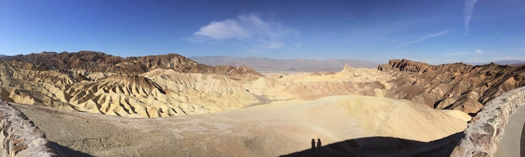
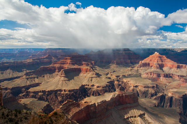
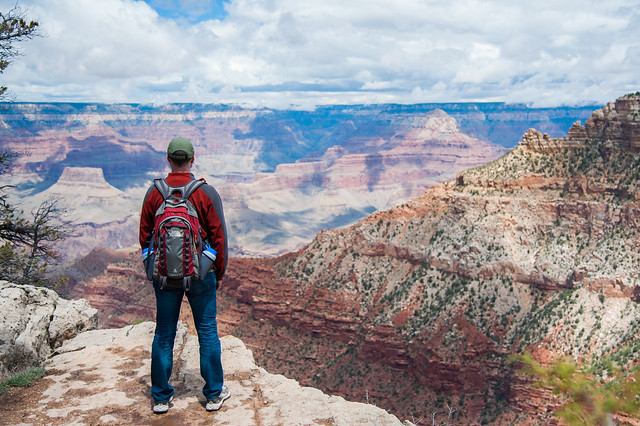
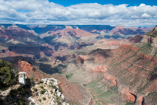
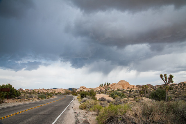
From the Grand Canyon, we headed for Page, AZ.  This town is situated among many popular attractions, like the famous horseshoe bend of the Colorado River and Antelope Canyon.  You could spend a number of days here seeing all of the sites and exploring the beautiful and at times other-worldly scenery here.  Even 
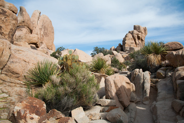
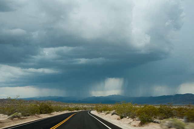
the rock formations along the highway into town are startlingly beautiful – we saw undulating hills and cliffs made of vivid oranges, pinks, purples, yellows, and even blue-greens.

Since our time was limited, we decided to check out Antelope Canyon while we were in town.  This canyon is on Navajo land, so all visitors are required to have a guide. We usually prefer to self-navigate through parks, but having a guide to tell us about the Navajo culture, history, and special features of the canyon was really useful and made our visit more memorable.

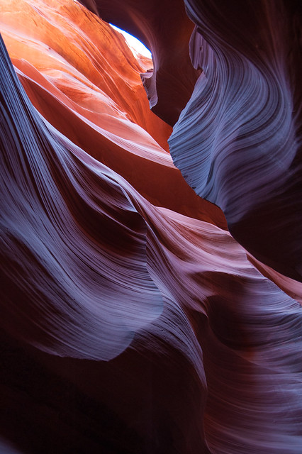
Antelope Canyon is divided into two halves: upper and lower.  Separate tour companies have guides for each, so we decided to see the slightly less-popular lower Antelope Canyon.  To get into this canyon, you have to climb down a series of very steep ladders.  Once you do, though, you are about 30 feet down in a slot canyon made of Navajo sandstone, some of the softest stone in the world.  Over time, water carved away the canyon walls in remarkable swirling shapes.  Our guide, Van, said that the canyon still has very dangerous flash floods about every 3 years.  These floods are so violent that they can tear away whole chunks of wall and smash boulders into the sides of the canyon walls (we saw examples of both from previous flooding). 

It took about an hour to walk through the entire canyon, stopping every few feet for photos and for information from Van.  He pointed out many rock formations that the Navajo have named for their resemblance to animals and people, and he also told us a little about how the Navajo had traditionally used the canyon for shelter, water, and protection from enemies.

As the sun lights the canyon walls from above, the sandstone reveals a breathtaking rainbow of colors and undulating forms.  Photographers have flocked here for decades because of the almost surreal colors created by the light here.  I was surprised at how vivid the colors are in person, having assumed that most of the professional photos I've seen had been drastically altered in photoshop.  While I'm sure some of them have been, the canyon light does do seemingly magical things to the color of the stone.

Untitled

The Grand Canyon

We arrived at the Grand Canyon to discover that the South Rim where we were camping is actually at 7,000 ft elevation. This meant that the weather was still pretty cold in mid-April, with nighttime temps dropping below freezing, and daytime temps just barely cracking 50 degrees. Luckily, we were prepared with wool hats, gloves, and down sleeping bags.

We were less prepared for the big storm that rolled through the area on our first day in the park. All the weather reports seemed to agree that the storm would last all day, with a mix of rain and snow. We decided to head to Flagstaff for the day and avoid our wet and chilly campsite. We checked out the Lowell Observatory, and then headed for a couple of coffee shops in downtown Flagstaff to watch the storm and catch up on emails and photos. The rain turned into a pretty significant snowstorm in the evening, and although our tent was encrusted with ice and snow when we returned after dinner, all was well at our campsite.

The next morning brought temps above freezing, so most of the snow that had accumulated during the night melted before 9am. We decided to spend the day walking the rim trail along the southern canyon wall, and a short stretch of the South Kaibab trail down into the canyon. It was a beautiful day for a hike! 


Untitled
Remaining thunderstorms along the North Rim

Untitled
Matt surveys the landscape

Untitled
Nice views and pretty clouds all day from the South Rim

Untitled
Elk where everywhere -- this guy was having lunch right on the trail

Untitled
Grand Canyon selfie!

A few more photos from the Grand Canyon can be found here.

Monday, May 4, 2015

Joshua Tree

After Death Valley, Joshua Tree was our next stop.  By comparison, Joshua Tree was pleasantly cool throughout the day and teaming with life.  Immediately upon entering the park, we were amazed by the forest of Joshua trees in the main valley.  They look like they belong in a Dr. Seuss book, and there are acres and acres of them as far as the eye can see.  We never quite got used to their strange shapes while we were there.

Untitled

Untitled

Untitled

Untitled

We were lucky to grab a really cool campsite when we arrived at Jumbo Rocks campground.  Site 113 is recessed from the road and nestled among some of the park’s giant rock formations.  We enjoyed climbing up to the top of our little boulder piles and surveying the landscape periodically.

 
Untitled
Our campsite and view over the camgrounds

Untitled
Matt surveys the landscape on our first night

We learned that these rock formations are all granite, which makes them very easy to climb.  We saw tons of rock climbers while we were in the park, and we did a little bouldering ourselves. A good explanation of how the rock formations were created can be found here.

On our first full day in Joshua tree, we explored the upper half of the park, which is part of the Mojave Desert.  We opted to do lots of shorter hikes instead of one longer one so that we could see many different areas in one day. We were struck by how much life there is here, and how many diverse species live in this area.  We saw lots of lizards, cacti, quail, humming birds, doves, cottontail rabbits, a (supposedly rare and endangered) desert tortoise, and much more.

Untitled
Cottontail rabbit at the Oasis of Mara

Untitled
Paper Bag bush at our campsite

Untitled
Cactus along the Indian Cove trail

Untitled
Desert Tortoise outside the Black Canyon Ranger Station

Untitled
Tons of lizards everywhere; this guy was on the High View trail

Untitled
Yucca and other cactus along the Hidden Valley trail

Untitled
Cactus blooms along the Barker Dam

Untitled
Wildflowers at Indian Cove

Untitled
Cactus blooms along Skull Rock trail

Untitled
Succulents by the campsite

On our second day, we headed south.  The park spans the border between the Mojave and the Colorado Desert, with the transition zone between these two ecosystems bisecting the park roughly in half.  The Colorado Desert looks very different from the Mohave; instead of Joshua trees and boulder piles, Cholla Cactus dominate the landscape. 

Untitled
Ominous warning sign at the Cholla Cactus Garden

Untitled
The Colorado Desert

The second day also brought some isolated thunderstorms, which briefly added some drama to the desert sky.  Luckily they passed quickly and didn’t dampen campsite too much (an added bonus being that they washed off some of the bugs from our car!).

Untitled
Driving north along the Pinto Basin Road

Untitled
Dark clouds over the campgrounds

The full set of photos from Joshua Tree can be found here.